

by CJ Haggard, Library Assistant
The Massachusetts Historical Society holds a remarkable set of liquor license petitions from eighteenth-century Boston. The petitioners wrote to the Boston Selectmen and the Court of General Sessions of the Peace for Suffolk County in the hope of obtaining a license to retail liquor or keep a tavern. Of the petitions, sixteen are written by men and nine by women, with each detailing the particular circumstances and requests of the petitioners. The petitioners give the reasons they must obtain a license, describe how neighbors and friends are willing to help them get started, and ask the Selectmen and the Justices to look on their situations with compassion. Most interestingly to me, however, is that most petitioners specified the location of their proposed tavern or shop, whether it was a rented venue or their own house.
While looking through these petitions, I had the idea to map each location to identify patterns and see their modern-day position. Using the Norman B. Leventhal Map & Education Center’s digital 1769 map of Boston with a modern overlay, I successfully mapped the locations of most of the proposed liquor-selling locations in the petitions held by the MHS. You can view them on Google Maps or on the map below.
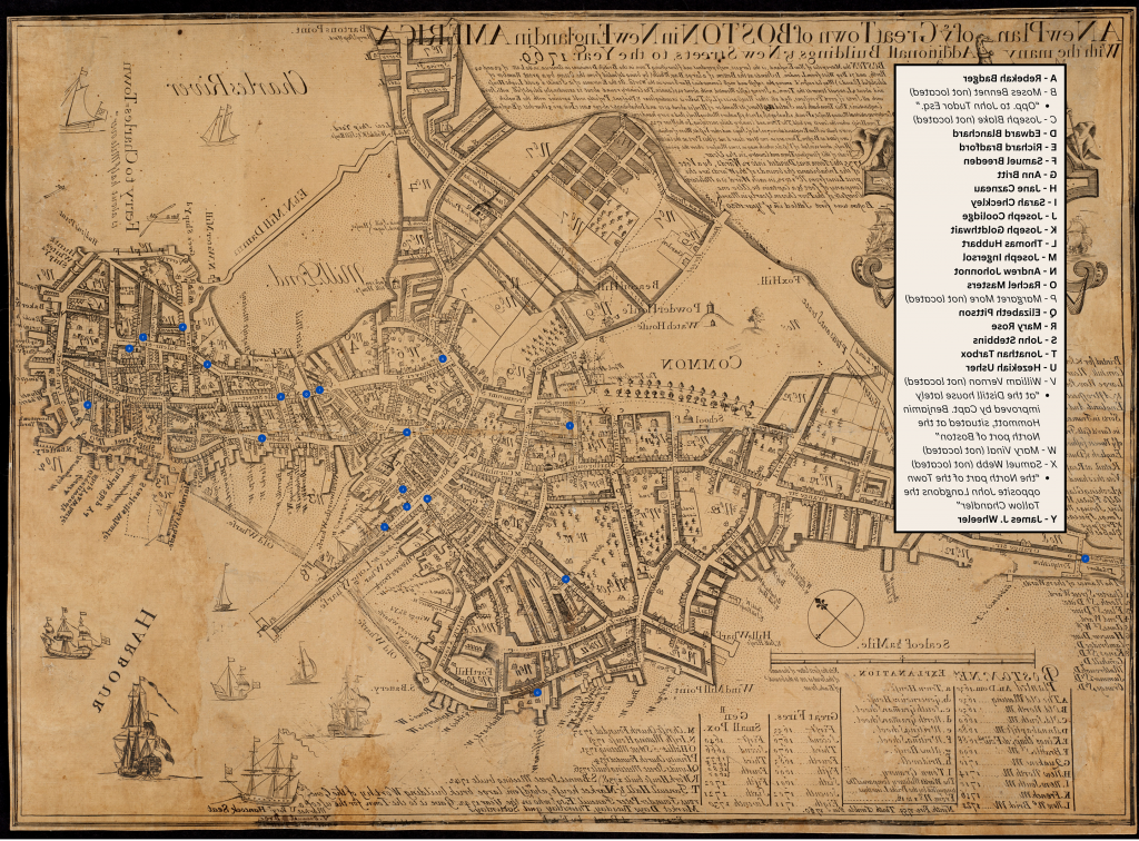
Historic map from the Norman B. Leventhal Map & Education Center; additions by CJ Haggard.
The map I made reveals that these institutions were spread out around colonial Boston, ranging from the North End to Boston Neck. The locations are not exact, as I often had little to go off of other than a street name or nearby landmark. A few petitions are also missing from the map, as they either did not give a location or I was not able to figure out where they were based on the directions provided. These petitions are noted as such in the key.
I also enjoy looking at the map and seeing what stands there today. For example: Joseph Goldthwait’s house, where he kept a tavern “for the Accomodation of Gentlemen from the Country,” would have been remarkably close to the modern-day location of Bova’s Bakery, a favorite of mine. Although it is unclear exactly where his house stood in 1767, he describes his situation as being “in back Street leading to Charlestown Ferry.” The end of Back Street (now Salem Street) closest to the Charlestown Ferry is exactly where Bova’s is today.

Photos by CJ Haggard.
The Admiral Vernon Tavern, or the Vernon’s Head Tavern, also has a modern equivalent. Thomas Hubbart’s 1764 petition describes the tavern as being on King Street, now State Street, which led from the Old State House down to Long Wharf. In The Crooked and Narrow Streets of Boston, Annie Haven Thwing goes into more detail about the tavern’s location, stating it “was on the northeast corner of Merchants Row.” Merchant’s Row still exists today by Faneuil Hall. Even more excitingly, the lot at the northeast corner of Merchant’s Row is a modern-day bar called Clarke’s at Faneuil Hall, mirroring its colonial use. Although the Admiral Vernon Tavern is no more, one only needs to visit Clarke’s to walk in the footsteps of Thomas Hubbart himself.
I hope my map sparks some interest in these incredible petitions in our collection. The peek into colonial Boston they provide is fascinating, and I encourage anyone interested to visit the MHS and learn more.
Further Reading: On our library catalog ABIGAIL, you can view listings for Joseph Goldthwait’s petition and Thomas Hubbart’s petition. If you would like to view the listings for other petitions, you can click on the “Taverns (Inns) Massachusetts Boston” subject heading attached to both Goldthwait’s and Hubbart’s listings. All petitions appear in our holdings of Miscellaneous Bound Manuscripts from 1764 to 1773.